Prototype
|
My friend started a retro computer museum called the Bloop Museum a few years ago. Unlike many typical museums, his museum keeps historic computer in working condition. The visitors can actually use them. It is not just watching computers sleeping in a glass display case. That's how unique his museum is. Maintaining all those collections in working condition must take a substantial work.
He is also knowledgeable in Japanese historic computers and he is starting a Japan exhibit. So, I donated one of my FM77AV40s. I still have AV40 and AV. Good enough for testing actual hardware when necessary.
The Bloop Museum is located in Maryland outside Baltimore. It takes 4 hours drive from Pittsburgh. But, he told me he was going to pick me up if I fly to Westminster Carroll County Airport (KDMW). So I flew. I needed to drive 1 hour to Beaver, and then 1.5 to get there. The return flight was due to headwind took 2.3 hours. Time saving is 1.5 hours to go, less than an hour to come back. But, flying is much less tiring than driving. Beaver Valley Flying Club's Cessna has an auto pilot. Once I climb up and trim, it flies by itself. It is much easier to reserve an Cessna all day than before when I was renting from a flight school. Nonetheless, I needed to reserve early. I reserved a Cessna for December 15 based on the 10-day forecast.
But, the weather changed quicker than originally forecasted. About 5-day before the flight, the forecast changed to cloudy. In winter cloudy means icing risk. Club's Cessna does not have an anti-ice equipment. It is too risky to fly into cloud. If I can fly lower, the air temperature may be above freezing, but to cross Appalachia I have to go up to 6000 to 7000ft. The condition might not be flyable. That's what I thought, and the global climate change came into play. The surface temperature was unseasonably warm. And then strong south wind brought in warmer air in higher altitude and making a phenomenon called temperature inversion. Actually the air temperature was warmer than surface at around 6000 to 7000ft, exactly where I had to fly. I was a bit skeptical about this forecast. It looked too good to be true. But, all the forecast sources indicated flyable. It was a go!
I took off Beaver County at 10am. I filed an IFR flight plan via St. Thomas VOR (THS) then SCAPE intersection then GPS direct to KDMW. It is easier to fly IFR on cross country, especially because KDMW is within 60nm of Washington DC VORTAC. It is outside of the DC Special Flight Restriction Area, but it still requires a pilot to finish a online course before flying into the region. It is not as free as in Pennsylvania to fly there. The easiest thing to fly there is to fly IFR. As it was described "Washington DC SFRA is transparent to IFR traffic" in the course. At Beaver county, I received an IFR clearance as filed. That was easy. But, near Johnstown, I received an amendment. The ATC gave me Hagerstown VOR (HGR) then Westminster VOR (EMI) and then direct. I think it was the first time I received an amendment in the air. Must be a busy airspace. Soon I was handed off to Potomac approach. Potomac approach told that there was an overcast cloud layer at 3500ft over KDMW, and asked what approach I wanted to fly. Just in case, I requested GPS 16. The ATC granted, and told me to fly direct UNYTS intersection, which was the final approach fix. I punched in UNYTS in IFD 440 flight management system. Soon I was told to descend to 3000ft, and cleared for GPS 16 to KDMW. I selected GPS 16 via UNYTS interesection in IFD 440. I broke out of cloud while descending to 3000ft. I had the airport in sight. I could just land visually, but since I was cleared for GPS 16, I continued on to UNYTS intersection. I meant to follow the localizer and glide slope. I was fully expecting the approach to become active before reaching UNYTS intersection. But, the localizer didn't appear. UNYTS intersection was coming closer and closer. Still no localizer nor glide slope. OK. Something was not going right. I deleted all the waypoints in IFD 440, set direct to KDMW and re-selected GPS 16. Instead of GPS 16 to be active, IFD 440 told me to fly to KDMW. Then make a left turn to fly direct to UNYTS and then fly GPS 16. OK. Fine. I was way below cloud, the airport was in sight. I landed visually.
Damn it! What if it were in actual IMC! Well, I would have called a missed approach and try again. But, it's not very comfortable for sure. I flew the same course after Hagerstown in IFD 440 simulator on iPad. Looks like if I selected GPS 16 via UNYTS intersection, IFD 440 apparently assumes that I was going to fly a full approach, in which case I had to fly procedure turn and then follow the localizer and glide slope. I think Garmin 430 still had an option to manually activate the approach, but somehow IFD 440 does not seem to have it unless I selected visual. Also another unfortunate thing was UNYTS intersection was already in the waypoint list. Therefore the approach did not become active until I hit UNYTS intersection. If I selected vector to final when I entered GPS 16, I was supposed to see Activate-Approach button, and IFD 440 did not expect me to fly a full approach, and I still could see the path to UNYTS intersection.
My friend picked me and my passenger at the airport. I was able to safely airlift my FM77AV40. Only thing I had difficulty was getting fuel at the self-service fuel station at the airport. The hose didn't lock and pulled me all the time, and I almost fell several times while climbing up the ladder. Was there a lock lever somewhere? I couldn't find one.
The museum was very interesting. There were many Japanese computers including X68000, PC9801, MSX2 etc. His PC8801 was still in the closet. My FM77AV40 joined the line. One impressive display was the world first graphical workstation Xerox Alto in working condition. The graphical programs were not available, but at least I could see it booting up and accepting commands.
I took one of my cartridges for MSX2 to test with actual hardware there. I bought this cartridge from Beep Akihabara a few years ago. I didn't know that "The Cockpit" had been ported to MSX2 until then. I was able to make sure it still runs with a MSX2 in the museum.
I took off KDMW almost close to 9pm. KDMW does not have a control tower. Instead, it was supposed to have a Radio Communication Outlet frequency, from which I was supposed to be able to get IFR clearance. Nobody responded my IFR clearance request. To prepare for this situation I bought an adapter to connect my iPhone to my headset. It worked, and for the first time I received a clearance over the phone. I knew I could do it, but I had never had to do it this way until this time. I was glad I prepared for it.
I filed just a reverse course for the return flight. But, the clearance I received was "Fly through controlled airspace via Westminster VOR (EMI), then radar vector to Martinsburg VOR (MRB), ELGEE intersection, Indianhead VOR (IHD), NESTO intersection then direct." First I mis-copied Martinsburg VOR as MRV, but the ATC caught my read back, and corrected me. I took off, passed EMI, then the ATC told me to fly direct IHD. So, actual path was simpler. Due to 30kt headwind, it took 2.3 hours to Beaver. It was nice to be able to enjoy my retro computer and flying hobbies one day.
This flight made my total flying time in 2021 to 46.3 hours. My goal is to fly 50 hours per year, but I couldn't reach this goal for the past many years. I tried to fly twice more to get to 50 hours. But, I had to cancel the first flight due to strong wind, and the second due to rain, low cloud, and visibility. Unfortunately I couldn't reach 50 hours. Maybe next year.
The view from above Pittsburgh downtown at night on July 4th was nothing but spectacular. Fireworks all around. Of course, the downtown fireworks was the most impressive, but fireworks from local shopping malls were also of great quality. In Pennsylvania, an individual can buy a quite large fireworks, too. Those individual fireworks were also making flowers of lights everywhere.
I video-recorded from my Cessna with my iPhone, which was pretty good. But, I regretted that I didn't carry a better video camera. I then was going to rent a Cessna from Nice Aviation and fly over San Francisco later July. I didn't want to miss it. I invested on GoPro HERO 9.
I actually was avoiding GoPro. Why? They are stubbornly using what's called the rolling shutter. Single-engine Pilots over the world are complaining and they don't listen. The rolling shutter makes the propeller miserably bent and divided into pieces. The workaround was to put a ND filter to intentionally slow the shutter speed, so that the propeller rotates at least several times during one frame. But, it is impeding the camera's performance. It's a bit uncomfortable, but if many pilots are satisfied with the solution, and also after seeing some videos on the internet, I decided to go for it.
I wanted to test it before actually using over San Francisco. So, I used it during the flight to Columbus OH. I had two concerns. One was how long the battery could last? GoPro officially tells it runs for about 2 hours. But, it was if you turn off pretty much every features except recording. I was going to fly over San Francisco. I wanted to capture the GPS track as well. I didn't know how long it was going to last with GPS enabled. The second concern was overheating. I saw numerous pilots complaining about overheating GoPro. If you put it on the dash, since no wind blows on it, GoPro gets quite hot, and eventually overheats and shuts down. Some were pointing that what's heating up was battery. It won't shut down if you draw a power from external source. Can external power prevent overheating? I wanted to test it.
I started the engine as usual, but this time, I had GoPro HERO 9 on the dash, instead of the VGA quality digital camera. I did pre-takeoff checklist, then, connected USB power bank to my GoPro, and pressed the record button. Then, my GoPro immediately shut down. My USB power bank was good enough for charging iPad. Nonetheless, 2.4A output was not good enough for GoPro. External-power failed from the beginning. So, instead, I put the battery on, and started recorded.
The battery was decreasing 1% per minute. Actually, interestingly, it was almost exactly 1% per minute. The continuous recording time was about 100 minutes. Probably it was long enough for the scenic flights over San Francisco, but to be safe, I decided to get an additional battery.
Overheating problem didn't occur while I was at high altitude. There was no issue at 8000ft. Although the sun was directly shining on my GoPro, cooling from outside air apparently was good enough to keep it running. As I came close to Columbus, the ATC gave me lower altitude. As I descended, the cabin temperature went up notably. Still GoPro lasted until landing, but as soon as I landed and exited the runway, it shut down due to overheat.
I needed a cooling fan. So, I made a prototype with my 5V cooling fan. I mounted the cooling fan on a plastic plate, and I cut out a rectangular hole on the plastic plate so that GoPro mounting bracket can go through, and I sandwiched the plastic plate with the mounting base and the GoPro body.
Prototype
But, I didn't have any more flight scheduled before the San Francisco flight. So, San Francisco bay tour was going to be the first test of my cooling fan. By the way, I was able to buy one GoPro battery from Best Buy just in time before leaving. I searched abound, but Best Buy was the only shop that had a battery in stock. It was surprising, other shops like Target and Walmart didn't have a single GoPro HERO 9 battery in stock although they were selling the GoPro HERO 9 camera. In these days, retail stores are not making money because many people shop from online stores. But, when I need it now, I still rely on those retail stores. Best Buy saved my day this time. Target and Walmart didn't :-P
During my San Francisco trip, I had two flights scheduled. Probably I didn't have to drive all the way to Reid Hillview airport. There might be a flight school closer to San Francisco, but I happened to be reading a blog of the chief instructor of Nice Aviation. So, I rented a Cessna from there. The first flight was to Monterey. GoPro didn't overheat during the 1.6-hour flight. The second time was over San Francisco downtown. I flew through the airspace dungeon to get to the San Francisco. GoPro worked fine for about 1.2 hours, but while I was descending to the downwind leg for landing, it shut down. But, apparently what was heating up was really the battery, not the camera body. Once I replaced the battery, the camera was able to resume recording. Once cooled down on the ground, the battery that overheated still had about 20% charge. I think my cooling fan extended the life of the battery, but 80 minutes were maximum. In fact, I was heading south on the way back from the downtown, so the strong sun over California was directly shining on the camera. If it was getting the direct sun on the way to the downtown, it could have given up earlier.
That's a summary of the San Francisco trip I mentioned in the earlier post.
I had one more scenic flight scheduled before the fall semester. I was going to take my friends to Niagara Falls. This time, since I wanted to take a video of the falls, I mounted my camera face down. I didn't have to record a long video, I only wanted to record while over the falls. It was not as severe as over San Francisco. Still inside the cockpit with no much air circulation. If the camera was heated by the sun before reaching the falls, there was a possibility that the camera was not usable then. Also, the pattern over the falls is right turn. I had to mount the camera on the other side of the PIC side. It was going to be difficult to replace the battery once I was strapped in.
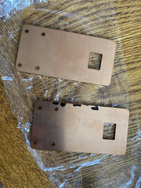
So, I made the complete version of the cooling fan. I used a metal laser-cutting service from OSH Cut. The shape of the plate is following. You can download the .SVG file if you want to try yourself. The idea was to use the copper plate as a heat sink. The last plastic plate was rather preventing heat from dissipated from the bottom side. But, this time, the copper plate should give a much better cooling.
And, the below image is the copper plates I received. The edges of the plate was not smoothed, so I scratched plates against each other to round out the edges, not to cut my hands. Then, I fixed the plate on the vice, and bent so that the plate doesn't obstruct the mounting screw. The cooling fan needs to be on the left side of the camera, or I cannot replace the battery. Depending on the configuration, you may have to put the mounting screw on the same side as the fan. It's a good idea to make room for it.
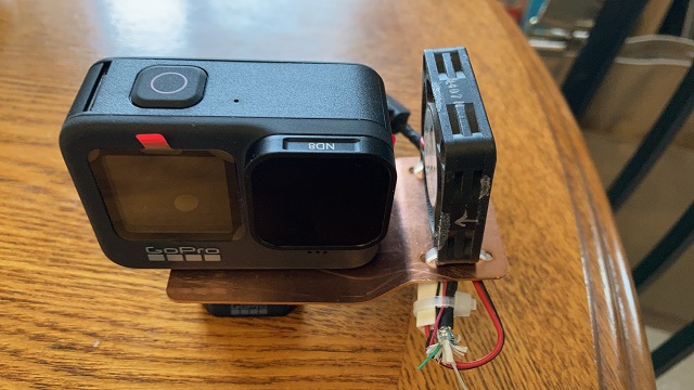
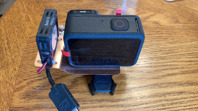
After postponing the flight twice due to maintenance, I finally was able to fly on 8/20. I cannot tell exactly at how low angle that the falls will appear from my Cessna before getting there. So, I just made a guess of the face-down angle. I filed an IFR flight plan going through JHW, Jamestown VOR to KIAG Niagara Falls International airport. I could have flown GPS direct. But, the regulation requires to have a floating device if I fly beyond gliding distance from a shore of a body of water. My Cessna doesn't have such floating devices. The direct course from KBVI to KIAG will bring me to somewhat close to the gliding distance from the shore of lake Erie. To be safe, I flew via JHW VOR.
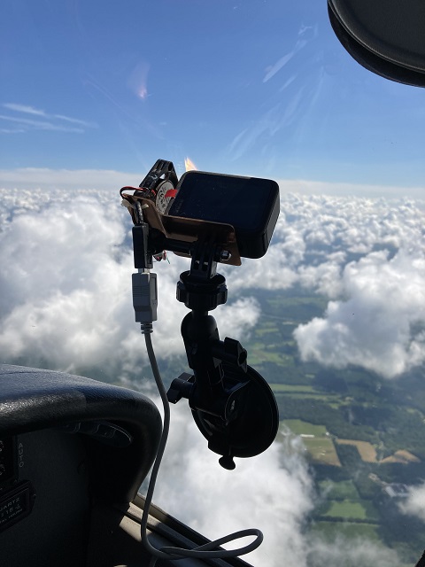
Since I didn't have to be worried about my video camera near the falls, I started recording over lake Erie. I was hoping it to continue recording without overheating.
There is a pre-defined course for scenic flights. The problem is, it is not very easy to spot landmarks for non-local pilots. One of the landmarks is a gold course, but I was looking at a different patch, thinking it was the golf course. It is easy to spot observation towers, and buildings near the falls. Also the falls can be spotted from far away by the massive mist over the falls. I somehow managed to enter the pattern correctly (I think). But, next time I hope I can spot the golf course correctly.
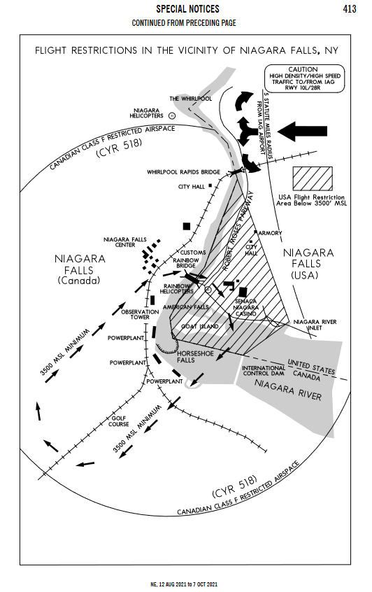
The next problem is where to turn outbound. The rule tells not to fly north of the Rainbow Bridge. But, the graphical description implies I am supposed to fly immediate north of the bridge. I am guessing some pilots who didn't read the textual description in detail might have flown a little north of the bridge. The bigger problem was, the Rainbow Bridge was totally hidden by the engine cowling when I was supposed to start turn outbound. Natural instinct is to lower nose and visually look at the bridge, but if I do that, I lose altitude. Since I was on IFR flight plan, Buffalo Approach told me to stay 4000ft, but as I tried to look at the bridge, I unintentionally was lowering the nose, and noticed I was at 3700ft! I added power and came back up, but I had to make a guess on when to start turn outbound. Actually, from the left seat, I cannot see the falls well either, so, really I had to make a guess. I think I didn't have to turn that early in the first round, the second round was reasonable, I think, and after the third round, we headed to KIAG.
After landing, my GoPro was still cold. I think my cooling fan worked very well. I continue to use VGA resolution camera for regular flights, or my disk will explode, but for a special one, I'm going to use GoPro from now on. If I can fly July 4th again, maybe I should put two more GoPros to videotape all around the airplane. I'll see.
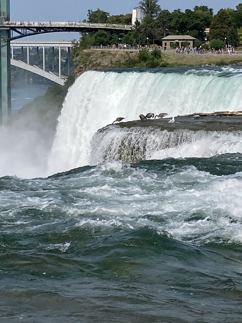
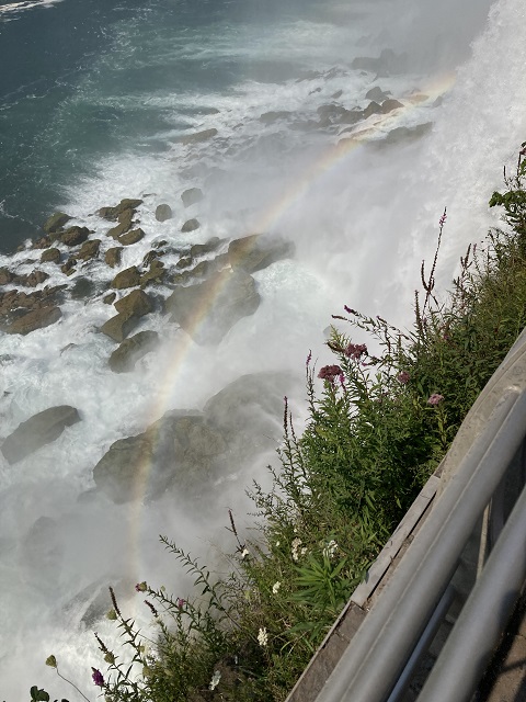
I had been to San Francisco for 9 days.
The United States is really re-opening for business. We do have some concern from COVID Delta strain. However, except the communist-made fake vaccines, numbers are telling real vaccines are very effective in preventing death and serious symptoms. It is good enough to me if I am protected from death, serious symptoms, and long-lasting health problems. At this time, we don't have a good data to judge if the vaccines are effective against long-lasting health problems, aka long-COVID. We don't have good data mainly because long-COVID is not well defined. Some define as a symptom lasting more than six weeks. I'm ok if the symptom is gone by the seventh week. Some study ended up including very light symptoms, which I don't care. So, I cannot draw a useful conclusion about long-COVID from the available studies. However, I think it is very unlikely that the vaccines protect against death and serious symptoms but not protect against long-COVID. Overall risk of me getting a serious health problem by COVID, or transmitting COVID to someone else is low.
We were eating, shopping, driving, and flying. First of all, my wife and I are from Japan and love seafood, but we are living in Pittsburgh, hundreds of miles away from the ocean. We were looking forward to eating good seafood there. Probably we can eat similar-quality seafood in Pittsburgh if we go to a pricy restaurant. But, human sense is influenced by the environment. Waking up to voice of seagulls and smell of ocean breeze give extra boost to the taste of the food. Being there makes a difference.
Except one morning, we had a breakfast at Boudin. We are a big fan of the sourdough bakery in the Fisherman's Wharf. Clam Chowder and Crab Chowder in bread bowl were delicious. Then we were exploring around Fisherman's Wharf one day, and then drove relatively long distance the other day. When we were not driving far, Japan Town of San Francisco was also our favorite destination. We browsed Japanese books in Kinokuniya bookstore and had good Takoyaki.
By the way, I renewed my camera for air shows. I had been using Olympus E-3, 50-200mm telephoto lens plus 2x tele-converter for 10 years, but the technology is getting outdated. I upgraded to Olympus E-M1X and 100-400mm telephoto. I carried it to San Francisco to test-shoot with Pelicans. E-M1X has a bird recognition. I wanted to see how good it was. So, I enabled bird-recognition and just used the default shooting mode (Program mode). Although there were many failure shots, some pictures came out very sharp. If I am aiming a high-flying bird with sky as background, it tended to give me a sharp picture, but when I was shooting down and the background was a ocean surface, it tended to miss. I think I should have selected faster shutter speed. Even if I choose to measure brightness at the center, the camera still is influenced by the overall brightness. When the background is the ocean surface, because the camera gets less incoming light compared to the sky, it slows down the shutter speed to compensate for it. Then the performance of the shake-reduction comes into play. Earlier Olympus shake-reduction was hilarious. If I shoot a moving target without turning off the shake reduction, the camera moves the sensor to the other direction of the motion, resulting a crisp background and blurred subject. E-M1X's shake reduction is smarter, and it detects a constant motion and disables shake reduction in that direction. I think the right way is to filter out low-frequency component, but somehow Olympus is looking at velocity directly. Nonetheless, the shake-reduction was not able to compensate enough for the low-flying birds. I guess I need to play with this camera more. Once I get used to it, I feel that the camera will give me nice crisp pictures.
During the stay, we visited San Jose three times. The first time was to meet with a CMU graduate and his fiance who both graduated CMU two years ago. He is definitely within the two best students I have ever met in CMU. I often text him talking about retro computers, but it was good to meet in person. It was very nice to see them doing well and healthy. He is proficient in multiple CPUs, FPGA, and hardware. He is really bullet-proof. In fact, when I get a question about a retro hardware, he is the person I ask first. It is a very unique opportunity to work for Carnegie Mellon to meet with and learn from such an exceptionally outstanding student.
San Jose is about one hour drive from the hotel. One of the things I wanted to do was drive on the California freeway while playing the BGM from SEGA Out Run. It was, I think, the fifth time for me to come to San Francisco, but somehow I couldn't do this due to numerous reasons. This time I made sure to copy the soundtrack to my iPhone, and the car had CarPlay. I was able to play from the speaker of our car. By the way, I came to an agreement with the above-mentioned graduate that SEGA Out Run is the appropriate BGM for driving. And, its Latino music fit very well for California. Driving on five-lane wide freeway of California just brought back the memory of Out Run I played more than 30 years ago, I think it was 1988. Hmmm, the visual got much more realistic in 30 years. (No, it's just real!) I'm living in Pittsburgh known to have a lot of bridges, but none of them were of the scale of the huge bridge structures crossing the San Francisco bay. Fort Pitt bridge is no match for the Golden Gate Bridge. During the stay, I made sure to drive through Golden Gate, Bay, San-Mateo, Dumbarton bridges. Seeing ocean on both side of the road was a different sensation that I never feel in Pittsburgh.
By the way, links to Out Run soundtracks. (Amazon Japan)
Two other visits to San Jose was for flying from Nice Air Aviation at Reid Hillview Airport. Actually it was my second time to fly from Nice Air. The first time was in December of 2017. I flew Bay Tour, and I liked it. Actually, after watching Pittsburgh Downtown Fireworks on July 4th this year, I decided it is worth investing for a better quality video camera for special flights. I bought GoPro HERO9. (I left my E-M1X at hotel since it was too huge to use in Cessna cockpit.)
GoPro suffers from overheating problem if you mount it on the dashboard of Cessna, according to my search. I didn't want to fail to capture the view in San Francisco. So, I tested it on a flight to Columbus Ohio from Beaver County. According to my search, overheating is from the battery, and it is unlikely to overheat if I use an external battery. So, I tried it first. Turned out, my mobile battery couldn't supply enough current for sustaining GoPro HERO9 recording, and it just shut down as soon as I pressed the record button. However, it didn't overheat with the battery while I was high in the air, but it did as soon as I landed. That was in Ohio. I was worried about strong sunshine in California.
So, change of plan. I quickly fabricated a GoPro cooling fan. I hoped it could slow down the heating if not preventing. But, I didn't have another flight scheduled before leaving for San Francisco. I had to put this cooling fan for test during the flight from KRHV.
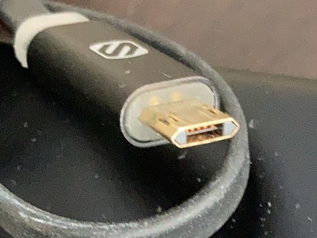
So, I was prepared, but had a problem when I got to San Francisco. I picked one of my micro USB cables, that's what I thought. But, the one picked, out of many micro USB cables, turned out a proprietary USB cable. What's evil about it was it fits the micro USB connector. I believe it came with my old Android phone for quick charge. I have a travel checklist that I go through before leaving for every trip. I did go through this time, too. But, I didn't make sure the cable was a real micro USB. Buying a supply at the travel destination gives a feeling of defeat. But, $5 micro USB cable was out of stock at nearby Target store, and I had to buy $10 cable, which added a feeling of defeat even more :-P But, I was able to charge my mobile battery.
The airplane I rented from Nice Air was N227AN. I fly N37MT from Beaver Valley Flying club, and when I talk with an ATC, it is 7MT, or "Seven Mike Tango." I was supposed to say 7AN, or "Seven Alpha November" there, but I almost said "Seven Mike Tango" to the ATC several times because I was too used to say "Mike" following "Seven", but succeeded in correctly saying "Seven Alpha November" all the time. Ahh, I think I didn't say "Seven Mike Tango", but I might have said it once or twice, and just forgot. The airplane had "朝日航空 (Asahi Aviation)" on the side. It apparently was once flying in Japan.
San Jose and San Francisco airspace is much more complex than Pittsburgh airspace. Immediately north west of the Reid Hillview class D is San Jose class C, which partially overlaps with San Francisco class B above. It's a dungeon to me. Plus, the airspace is very crowded with airplanes going in and out of San Francisco International airport. There is no way I can handle ATC communications by myself. So, I asked an instructor to fly with me. This time, Nice Air assigned a very energetic and enthusiastic CFI who was from Taiwan.
The original plan was to fly Bay Tour in the first flight, and fly over Apple HQ in the second flight. But, San Francisco Giants played the day originally planned, so we postponed by one day, and the next day was foggy over downtown and Golden Gate Bridge area. So, we decided to go for Apple HQ then Monterey area for the first flight.
ATC communications are very well standardized if you fly IFR (or instrument). But, if you fly VFR (or visual), it is not as standardized as IFR. There are local rules of the airport. Well, you can still fly without knowing all of the local rules. An ATC typically recognizes a visiting pilot is not local and accommodates for a newbie. But, when to say intention is very different from airport to airport. When I was training for my private at Chandler Municipal Airport (KCHD), I was supposed to say my intention to the Tower, but not to the Ground. So, I say "Chandler Ground, Cessna 19015 at Sunbird, ready to taxi for take off with Alpha." before taxiing and then "Chandler Tower, Cessna 19015ready to take off 22L southbound departure." before take off. Allegheny County (KAGC) was the same.
In my home base, Beaver (KBVI), I am supposed to say intention to both Ground and Tower. I'm supposed to say "Beaver Ground, Cessna 37MT at east hangar, ready to take off with Bravo, eastbound departure." before taxiing and then "Beaver Tower, Cessna 37MT, ready to take off 28, eastbound departure." before take off.
At Reid Hillview, I was supposed to tell my intention to Hillview Ground, but not to Tower. So, I was supposed to say like "Hillview Ground, Cessna 227AN at Discovery, ready to taxi for take off with Charlie", and then "Hillview Tower, Cessna 227AN, ready to take off 31R."
Last time, December 2017, I spoke just like I was doing at Beaver, and then Hillview ground spoke to me too fast for me to catch. I learned through my experience that if I speak slowly, the ATC tends to speak back slowly, too. Or, if I speak fast, it gives an ATC a false impression that I can get it fast. Probably the ATC at Hillview was speaking no faster than an ATC at Beaver then. But, my brain did not have a vocabulary to catch all the information then. So, this time, I tried to talk slowly to the Hillview ground, and it worked very well. I was able to copy instructions Hillview ground with no problem.
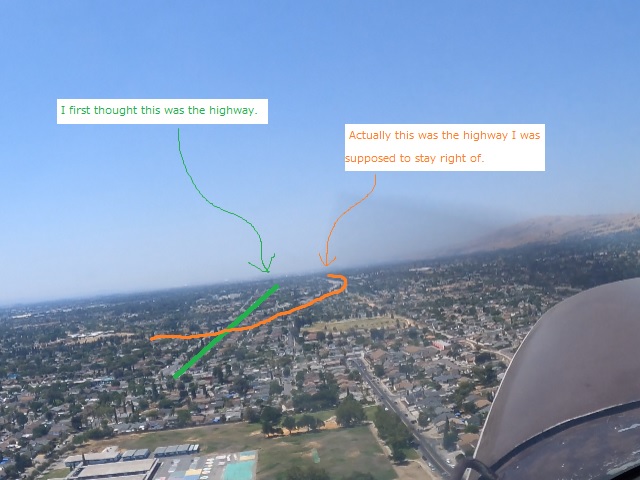
Taxiing, run-up went smoothly. It was my first time to fly a circular-gauge (aka steam-gauge, or six-pack) in almost two years. Last time I flew a circular-gauge was November of 2019. I was glad I still was able to handle it. I had to stay out of San Jose class C until I contact San Jose ATC, so the CFI told to stay right-hand side of the highway. And naturally I was looking at a different road. California roads are wide. That's exactly why I needed a CFI with me.
Apple HQ was very close to San Jose International airport, but it was off the approach and departure path. San Jose Tower gave us a permission to circle over the famous donuts building. Well, it's going to be too short to fly directly back to the airport, so we flew to Monterey area. California coastline is very beautiful, especially near Monterey bay. The ocean surface was mostly covered by sea fog, but that only added some beauty. Then flew over Salinas, where the living legend aerobatic pilot Sean D. Tucker is based, then back to Hillview. I tried to record the flight path with Flight Plan Go, but my iPad mini overheated, and lost most of the flight path. My iPad mini never overheated on my lap when I was flying around Pittsburgh. California Sunshine was intense.
Landing was an OK level, but I wanted to make it smoother. The airplane touched the runway while I was thinking to be still a little bit above the ground. I have a feeling that older model Cessna 172s are taller than later models.
It was a fun flight. It's a good experience to fly from an airport that I am not familiar with. By the way, my GoPro didn't overheat. My cooling fan worked!
The next day, we went to Japan Town, and bought a bunch of Japanese books from Kinokuniya bookstore. We didn't drive too far on this day.
The next day, my wife wanted to go to Buena Vista, which was famous for Irish Coffee. So we went for breakfast. That was delicious. There are too much good food in San Francisco. We needed additional stomach. We were discussing about going to Monterey Aquarium, but the web site was indicating no ticket was available for this day. However, when I checked the ticket availability again while waiting for the breakfast, there were a bunch. Probably there were cancellation, or they release some same-day ticket each day? So, I reserved for two. Waited for an hour to let my Irish Coffee go through my system, and headed south.
We drove the region where we flew two days ago. 2.5 hour driving was a bit tiring, but I felt I could drive indefinitely with Out Run BGM. Monterey Aquarium was packed. It was as if COVID hadn't happenned except everyone was wearing a mask. There was a nice funny T-shirts, parody of Harry Potter, featuring a Sea Otter with a Hogwarts uniform, titled "Hairy Otter". I almost bought it. But, I didn't. Now I regret I didn't. I have a reason to go there again. I think I statistically have near-100% chance of exposure to the infamous Delta variant. But, again, as I said above, I don't care as long as I don't die, getting serious symptom, or permanent health problem. If someone choses to not get vaccinated and get killed, that's their business, not mine. We drove through California Highway 1, famous for the the great ocean view. It was as advertised.
We came back to our hotel quite late. We had dinner at Cioppino's. I had Fishermans' Platter. It was nice! Tasted too nice! Too much good food there. I needed more stomach.
The next day, August 2. Our second flight was scheduled to August 3, but the CFI at Nice Air texted me and suggested to pre-pone to today, because the bay area was clear of sea fog. Well, but I was a little bit tired from the long drive to Monterey. We decided not to go today, and took a rest staying nearby. Instead of flying over the Golden Gate Bridge, we drove to the vista points of the bridge. It was just 20 minute drive from the hotel. It was huge. Fort Pitt Bridge was no match. Then we went to Japantown, had Takoyaki, bought a book, and returned to hotel. I was going to have an important meeting when I am back in Pittsburgh. I was finishing up a Power Point slides, and then realized I had to code a little bit for that, so I did.
The last day of the trip. I was supposed to fly a Bay Tour from Nice Air, but the Fishermans' Wharf was covered by sea fog in the morning. Now I see why San Francisco is called a fog city. But, blue patches were appearing when we left the hotel. I was hopeful and headed for Hillview airport.
From San Mateo bridge, Bay Bridge was clear. I saw another darker-color bridge, so I hoped the Golden Gate Bridge was also out of the fog, but turned out I was looking at a different bridge because Golden Gate was not visible from San Mateo bridge.
Unfortunately, the Golden Gate Bridge was still in the sea fog. If the sea fog was hugging the ocean surface, and if the bridge was visible over the fog, that would be a magnificent view. However, I knew the sea fog was already lifted to the broken to overcast layer when we left there. So, it was unlikely. What's the hell! I wanted to fly. So off we went!
Communication with Hillview Ground and Runup went smoothly. This time I was looking at the correct highway after take off. I was comfortable talking with San Jose tower (for Class C transition, I had to talk with San Jose Tower, not Approach.) I think I'm able to fly solo to the south. However, the airspace north of San Jose was a dungeon to me. I compare it with Shinjuku Japan Railway station. If you have been there, you must know what I mean. That's why I needed a CFI with me. As we came close to San Francisco International, ATC communication got very busy as expected. My speak-slowly strategy was no good for that area. At one point, Norcal approach told us to "Stay east of SFO." That's what I thought, and my CFI thought, too. But, we were flying west of SFO. To fly east of SFO, we had to cut across the approach path to the other side of the airport. We tried to confirm with the Norcal approach, but the ATC told to stay east of SFO again. Finally my CFI asked if the ATC wanted us to see highway 101 on the right, the ATC said so. We decided to disregard "east of SFO" and continued on.
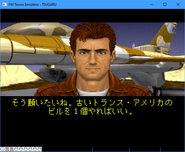
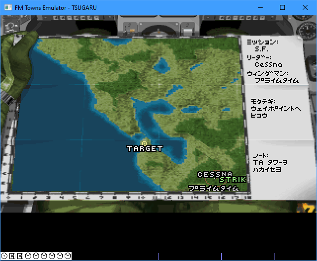
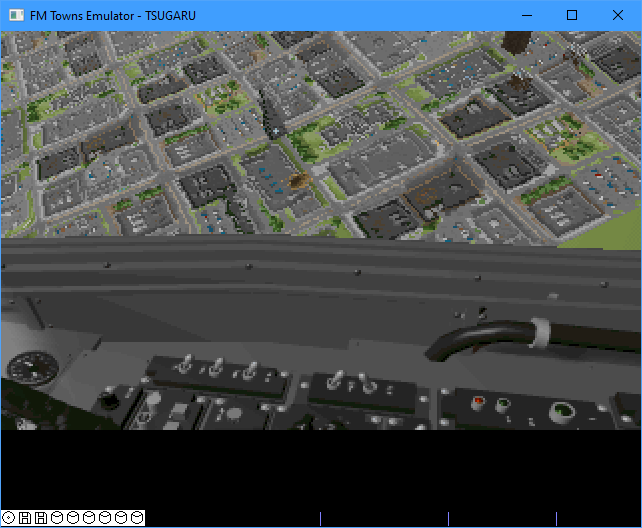
Then flew over downtown San Francisco. Last time I flew over San Francisco was in a mission of Strike Commander for FM TOWNS last year. It's one of my favorite classic flight simulators. I uploaded a video when I experimented if I could fly under the Golden Gate Bridge in that game (https://www.youtube.com/watch?v=N14XGFgwQjQ&t=37s). The Golden-Gate Bridge was half visible, half hidden by the sea fog. It was ok. It still made a great view! We descended to 1300ft over the ocean. 1300ft MSL is 200ft AGL in Pittsburgh, but 1300ft MSL is 1300ft AGL here! It's all fun! I noticed a pointy-top building in the downtown. Actually it existed in Strike Commander. I never realized this building really existed! In English voice, this building was described as a "pointy-top building." But, it was totally mis-translated in the Japanese port. So, I had tough time finding a target building in the FM TOWNS version when I played it 30 years ago. I got curious about what exactly the building was called, and found the following link. (https://en.wikipedia.org/wiki/Transamerica_Pyramid)
Wait. This building was also called as "Trans-America building" in Strike Commander as well. I did confirm by playing on my emulator.
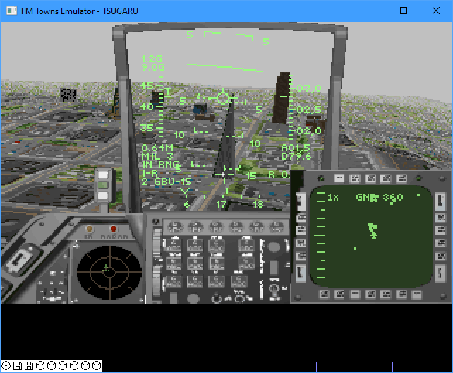
We flew over Oakland then back to Hillview. ATC gave us a bunch of landmarks to fly over. I remember the ATC told us to fly toward "Toll Gate". They meant the toll gate of the Bay Bridge. Then told to fly toward "Coliseum". But of course I didn't remember them. I had a same problem when I flew in Hawaii. I wanted to study all those landmarks to prepare, but I didn't find a resource. Well, Allegheny County tower uses Mitchell to the traffic coming from the south, but probably it's only known to local pilots only. There are local rules. I guess I need more experience to fly through this San Francisco dungeon. One day I want to be able to handle by myself.
While I was descending to the downwind for landing, GoPro shut down although 20% of battery was still remaining. It overheated. I was glad my CFI noticed it. If it was the overheating battery, it should come back to life if I replaced the battery. So I did, and it did come back to life. I missed probably 20 seconds or so, but finished the recording all the way. GoPro was worth an investment. 4K video was very impressive.
This landing was softer than the first one. I tried to stay just a touch higher than last time in flare. During the private-pilot training, I was told to fly just above the runway until it stalls, but if you want to make a soft touch down, you level off, then slowly descend. If you do it successfully, you won't sense the shock of the landing. You will notice the wheel touched the runway by the noise of the tire rolling. This one was not that nice, but I think it was better.
I felt that the downwind leg was very wide, but later I understood when I reviewed the video. The distance between two parallel runways of Hillview is pretty small. I don't want to overshoot the final and plow into the final of the other runway. It makes sense.
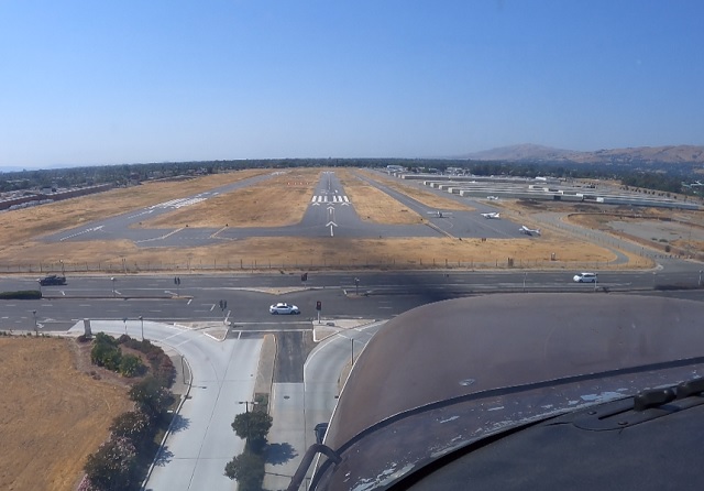
One last hiccup was after landing, Hillview ground told us to "Taxi to Discovery via Zulu." and I replied just "Taxi to Discovery." I should have included "via Zulu" but I omitted in read back. My CFI quickly pointed that. Agh! That was my bad habit. I'll try not to omit from now on, when I fly from Beaver or anywhere else.
After landing, we drove to San Jose Mitsuwa for the last time and had lunch at Paris Baguette bakery cafe. The quality of the pastry in Pittsburgh was boosted when La Gourmandine started, so we were not that starved for good pastry as before, but nonetheless we love Japanese-quality bakeries. (Ask Olympic news reporters.)
It was all fun after being stuck in Pittsburgh for 17 months. Since the Golden Gate Bridge was half hidden during the Bay Tour, I have a good reason to go back there next time.
If you are a pilot flying should be an agenda for your vacation. Unless you fly your own airplane for vacation, probably you fly in an airliner to your destination and shop for a local flight school. I recommend Nice Air Aviation at Reid Hillview airport if you want to see a spectacular view of Northern California. You can find contact at http://www.niceairaviation.com/.
One thing I've been wanting to do was watching July 4th Fireworks from the air. I couldn't do it while I was renting from a flight school because flight schools were closed on July 4th. But, now I joined Beaver Valley Flying Club. Regardless of holiday or not, I can pull out and take off as long as I can reserve an airplane. So, I did this time.
The view was absolutely gorgeous. Fireworks all around. The United States of America is fully open for business again! Downtown fireworks was spectacular. The fireworks exploding underneath was already special enough, but what's particularly special was I could see fireworks reflected on the river surface. The reflection is not visible from the ground. Also I could see all fireworks shows big ones and small ones, not just downtown fireworks. I saw relatively large one, that I presumed from Monroeville mall. Quite good one from Waterworks or Fox Chapel area. South side, Dormont, West Mifflin, fireworks were shooting up from everywhere!
Once the downtown show is over, I made a fuel stop at Allegheny County Airport. Also I did two stop and goes to extend my night currency. But, private individual fireworks were still shooting up. Some were directly from under the final approach course. I had to make a very steep approach to avoid being shot down. But, Allegheny County has a 6500-ft long runway, more than long enough for Cessna 172. I could actually evey shoot for middle of the runway, if I really needed to avoid anti-air artillery. That was fun, too.
By the way, Beaver County Airport is relatively difficult airport to spot. The landmark I use for finding the airport is the shopping center east of the airport. But, it is just one of many shopping centers. When I started flying from Beaver, I pretty much relied on GPS to find the airport. Nonetheless, after several years, I am able to distinguish the shape of the shopping center from the distance.
But, at night, it's even more difficult. If you have experience in night flying, you probably look for a rotating beacon, which flashes every a few seconds. So, you look at somewhere completely dark, and find a flash, which repeats at the same interval. That method doesn't work for Beaver. Why? Let's take a look at how Beaver County beacon look like at night. The next figure is when the beacon flashes.
![]()
And the next one is when dark.
![]()
There apparently is something bright immediately next to or underneath or above the rotating beacon. So, from the pilot point of view, Beaver beacon is always bright, but the brightness changes at the same interval. If you expect complete darkness and repeating flashes, you won't find it.
Happy New Year!
So far, I have:
Total Flying Time 713.4
Total Landings 1840
Total Night Landings 154
PIC 630.4
Solo 141.9
Cross Country as PIC 214.4
Night PIC 39.6
Dual Instruction 286.4
Dual Cross Country 30.5
Dual Night 26.3
Hood 111.1
Actual IMC 12.0
Approaches 285
Holdings 55
PCATD 5.3
Birds Killed 2 +1 unconfirmed kill (Rest In Peace....)
| Comments are welcome.
Send E-Mail to:
|